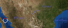

Rio Grande:
275 miles from Lajitas, Texas to the Pecos River
December 22 2006 - January 12, 2007
Crew:
Dr. Joan Gero - anthropologist, American University, Washington DC
Bob Guild - environmental attorney, Columbia, SC
Dr. Stephen Loring - anthropologist, National Museum of Natural History, Washington DC
Rob Mullen - artis, West Bolton, VT
Patricia Pepin - Quebec
Nena Price - anthropologist, University of Soutch Carolina, Columbia, SC
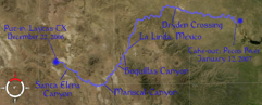
After paddling through Santa Elena Canyon and celebrating Christmas deep inside, Bob and Nena had to leave the river at Cottonwood Campground in Big Bend National Park on December 26.
Stephen, Joan and Rob continued through the park to La Linda Mexico, spending New Year's Eve in Boquillas Canyon. From La Linda Rob continued another 175 miles alone through the Lower Canyons to the Pecos River.
A Muddy River in Halls of Stone
(or Paddling West of the Pecos)
175 Miles on the Rio GrandeDecember 22, 2006-January 12, 2007
By Rob Mullen
As it turns out there is nothing quite like the sudden braying of a nearby jackass to put the end to a fitful night’s sleep. The New Year’s Eve celebration in the Mexican village upstream had been clearly audible far into the morning hours from our camp on the Rio Grande in Big Bend National Park. Giving up on any more rest (and needing to see a man about a horse), I got up to watch the sunrise wash over Boquillas Canyon.
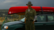
Dr. Stephen Loring, an anthropologist at the Smithsonian Institution, had suggested this trip in September while we were on the George River in far northern Quebec. I had wanted to paddle the Rio Grande for years, so when he called December 10 to say it was on for the 21st; I abandoned girlfriend and family for the holidays, loaded a spare Mad River solo canoe (mine is still hostage with an arctic shipping company) and left snowy Vermont for the Chihuahua Desert.
The canoe was from Mad River of course and in showroom condition. Brand Manager, Buff Grubb invited me to stop by the factory on my way down to prep it for wilderness travel. After a pleasant visit with Buff, I met up with the rest of the crew in Hondo, Texas. In addition to Stephen, there was his wife, Dr. Joan Gero an anthropologist at American University, Nena Price, an anthropologist at the University of South Carolina, and Bob Guild, an environmental attorney. We went to Panther Junction Ranger Station for our permits. The Park Service doesn’t overtly discourage solo travel, but a park ranger soberingly took my body ID photo to save the Park Service work if I ended up "face down" on my solo run. I obligingly posed and we were off for the put-in at Lajitas, Texas.
Upon our arrival at Lajitas, low water left the river small, muddy and smelling of dead fish. Anticipation of the journey nonetheless imbued the scene with an exciting aura aided by a pair of Crimson Flycatchers working the riverbank.
Underway the magic of being afloat took over completely and the mysterious lure of the upcoming bends and distant canyons exerted an inexorable pull as years of imaginings began to turn into reality.
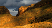
The second night we made camp at a magically awesome site just before the mouth to Santa Elena Canyon; an ominously gaping opening in a sheer rock wall like something out of Tolkien's Middle Earth. Early on Christmas Eve I headed up to the north rim to watch the dawn break across the canyon.
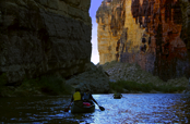
After a leisurely breakfast, the current carried our canoes through the narrow defile in the mountainside leading into the looming depths.
Passing into the towering walls, the outside world seemed shut out and an echoing hidden world opened up. The sense of isolation and incalculable age was palpable and on a scale beyond anything human. It was nothing like looking down into it. There was also the realization that we were committed to whatever the canyon had in store for us, which included three rapids, among them the notorious Rockslide. We approached Rockslide with some anxious anticipation but with a mixture of relief and disappointment, found that the low water had tamed it for the time being.
That evening we camped deep in the canyon on the Mexican side. Stephen set up a sprig of salt cedar propped up by river rocks festooned with ornaments he and Joan had brought for everyone and we sat around the fire roundly toasting Christmas. As I did for most of the trip, I didn’t bother with a tent, trusting the cold temperatures would keep the snakes, scorpions and tarantulas at bay. Full dark descended and the stars lit the top of the high canyon wall with an entrancingly evanescent glow.
As profound as paddling the deep cool echoing chasm of Santa Elena was, it was a pleasure to paddle out into the sun on Christmas Day.
Nena and Bob pulled out at Cottonwood Campground below Santa Elena. Stephen, Joan and I continued on, beginning the run to Mariscal Canyon. As evening descended, we camped on an island in tall Bermuda grass. Sans tent, I awoke at some small hour in the morning sheathed in frost. It was generally warm, even hot during the day but often freezing at night. Many paddlers skip the 50 miles between Santa Elena and Mariscal Canyons, considering it a dull Sargasso Sea of cane banks. However, aside from simpler logistics and bragging rights, there were frequent and ever changing views of the rugged Chisos Mountains against the soft frame of cane, numerous small rapids and birding.
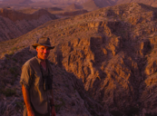
In five days, we reached the entrance to Mariscal Canyon and a lovely campsite on the Mexican shore. Stephen and I hiked up what we thought looked like a single easy ascent to a far ridge from which there would be a view into Mariscal. However, the uniform dun coloration of the desert hid a succession of increasingly jagged drops ending in a final towering precipice that stopped us dramatically. We couldn’t yet see into Mariscal very far, but the wild and chaotic geology was almost better for being such a surprise.At six miles, Mariscal is the shortest of the Big Canyons but you experience a canyon one vista at a time. It swallows you in as dramatically as any of them and being borne along on the current at the bottom of a rock chasm nearly two thousand feet deep makes an impression that is independent of the length. It also has three reputable rapids though the water was again too low for them to be challenging.
Beyond Mariscal Canyon, was Hot Springs and Rio Grande Village, a discordant (though convenient) outpost of civilization, which we reached late in the afternoon of New Year’s Eve. A relatively difficult rapid ended at the Hot Springs. After 100 miles of remote country, it was ever so odd to spin into the eddy behind the cement enclosed hot spring pool as I finished the run and have my boat held by cheering and brightly colored tourists. At the small general store, locals were buying towering piles of beer for the upcoming festivities. Stephen and I bought some Lone Star and we had a modest celebration in camp complete with champagne just above the entrance to Boquillas Canyon.
The next morning was the dawn of 2007 and brought the jackass mentioned earlier. Boquillas, at 18 miles is the longest of the three main canyons of Big Bend. While not as sheer as the other two, it is still very deep and it was to me the most beautiful of the Big Canyons; less dramatic but grander.
Shortly after Boquillas was the end of the Park and about 10 miles further one of the few roads to access the river crossed into La Linda, Mexico. Stephen and Joan had arranged for an outfitter to drive their car there late the next afternoon so that evening, a few miles from La Linda was their last night on the river. While it had still been clear during dinner, the few clouds were racing fast through the desert sky. Hardly comfortably into my sleeping bag, the patter of scattered rain started, soon followed by the flash and rolling rumble of thunderstorms grandly gliding past to the north. Watching the storm tops shine in the desert moonlight, I timed the interval between the lightning and the booming reports. The rain increased and I grew drowsy scanning for leaks (it had leaked badly in a storm a few days before) and drifted off hoping my tent would hold up or the desert would return to its purportedly arid nature by morning.
The drumming of hard rain awoke me early. The tent had made it through the night so I stayed in bed until it finally sprung another leak. The camp was accessible only by a steep brushy clay bank. It had been bad enough when dry the previous evening; in a soaking rain it was like hot butter on ice. Loading the canoes was a dicey operation. Stephen told me there was a fantastic inn at the Heath Canyon Ranch across the river from La Linda. As we paddled in the cold rain, he said he’d buy me a hot breakfast. I was really looking forward to that.
La Linda is a ghost town adjoining an abandoned ore processing plant. We landed on the US side in the chilly rain and clinging mud. A suspicious lack of activity and a soaking and forlorn aura presaged the "Closed" sign. The Inn had folded two years before and now the only person on either side other than the smugglers was Fred, the ranch caretaker. I found him having "Misty Mornings" (Canadian Mist cut with sugar and coffee) up at his RV on the hill overlooking the river. Stephen and Joan’s car arrived and they happily departed, leaving me alone in the dreary wet contemplating why I hadn’t gone with them.
Fred suggested I set camp on a concrete slab with a battered tin roof (the storm was the largest in 18 months) and came down later with his pit bull-greyhound mix, DD (Damned Dog) and offered me a beer. After shooting the breeze for a while, he drove me around in the ranch jalopy to see the sights. The storm started to break as we toured about and as the setting sun spilled breathtaking light across the land the idea of continuing downstream regained its appeal.
In the morning, I filled my water jugs at Fred’s spring. I’d been advised to carry all my water and had ten gallons aboard (a heavy load). Fred made me a Misty Morning and after a judicious sobering up interval, I started my solo run of the Lower Canyons.
The wilderness feel of the Rio Grande to this point had been sporadic. That changed in the Lower Canyons. The water was higher and cleaner, the rapids more numerous and difficult.
The first thirty miles were easy with some access to the outside (an 18-mile dirt track to the Black Gap Wildlife Management Area HQ). Past Reagan Canyon, the river turned east and entered the heart of the run; over forty miles of nearly unbroken canyon as much as 2,000 feet deep. This section includes the most challenging whitewater including the three biggest rapids; Hot Springs Rapid and Upper and Lower Madison Falls along with several other named runs. The scenic wonder of the Lower Canyons created a numbing sensory overload. No matter how much I looked and tried to take in, there was always more. Finally, I stopped trying and just let it all wash around me as I floated downstream. With no companions, my imagination sought company in my surroundings, imparting an animate character to the land and river. Not too surprising for an imaginative and isolated member of a social species, I wondered if this was how animistic religions got started; maybe I could start my own when I got back. Alone, I had the freedom to do as I pleased, but also knew I was working without a net.
In the nine-day 150-mile run to the Pecos River I saw no one except at Hot Springs Rapid. The hot springs there in years past have been a major attraction for paddlers and locals alike. I had, however, been advised to be through quickly and not to camp there.
I saw nobody as I scouted the rapid from the Mexican shore. It consisted of two drops and I saw a cheat route on the Texas side. It worked for the more difficult upper drop but relaxed vigilance and a heavily loaded canoe undid me in the second. In a slow-motion instant I found myself holding onto the aft of my canoe in a powerful current heading straight for a dangerously undercut midstream boulder (no upstream pillow indicated the undercut). Reflexively I had held onto my paddle in the spill (even my hat was still on) so abandoning the canoe to the impact I pulled myself just to the left to clear the rock. The flotation bags in the canoe kept it upside down and high, so as the bow struck, the stern swung left too. It hit me square in the chest and crushed me into another rock, the two of them working together to knock the wind out of me. My life vest, however, prevented any real injury and the impact actually pushed me into the eddy below the second rock from where I managed to snag the errant canoe as it passed and work to shore. Feeling both lucky and stupid I was finishing emptying the boat when I heard someone calling, “Hey, Cold Beer!” oh great – all these lonely miles and the moment I fall out of the boat there is an audience. Looking up, I saw a group of men on the Mexican side, smiling and waving, one of whom was holding a beer out to me. I felt badly for my paranoid worries, but being alone (and too cold from my swim to want a beer anyway) I waved, said no thank you and continued downstream.
In my hurried preparations Stephen had assured me, he had maps, in fact an entire guidebook to the Lower Canyons. He did, but we didn’t notice until we were on the river that it only covered the popular run from La Linda to Dryden Crossing. I had decided to save the money of an outfitter and see some extra country by leaving my car at the Pecos River boat access, 20 miles downstream of Langtry and so would have no maps past Dryden Crossing. Furthermore, we'd been told in Langtry that Dryden Crossing was only 20 miles upstream - it's 50 (this may be why men don't like to ask directions). As it turned out, what I imagined would be a 40-mile sprint to the car without maps, would be closer to 70 miles.
Dryden Crossing consisted of a tin roofed cement slab, a rough road ending in the river and a dead cow. After 19 days on the river, six of them by myself, the depressing desolation emotionally ended the trip for me. I stowed the now useless maps and resolved to end the trip as fast as I could and maybe even cadge a ride in Langtry for the last 20 miles to the Pecos. I camped several miles downstream of the road.
Happily, the scenery improved dramatically after Dryden Crossing, but to my surprise, despite making excellent progress the next day, I saw no sign of Langtry. Puzzled, I made a comfortable camp at the upstream point of an island and enjoyed a flock of turkeys walking past as I prepared dinner. Later, sipping whiskey and cocoa under the starry sky I reasoned that I would surely reach Langtry the next morning.
I was up early, and after another close encounter with the turkey tribe, was on the water less than an hour after sunrise. I paddled long and hard through beautiful country all day but there was still no sign of Langtry. I half jokingly asked cows I passed if they knew how far it was to Langtry. It was raining as I made camp in an enormous limestone overhang, sparing my tent the ignominy of leaking again. The deep gooey mud at the shore nearly ate me and though it improved at the rear of the overhang, considering how the clay stuck to everything in massive globs and the number of wild pig tracks, I slept in the canoe.
I was up early, my confidence renewed that today was the day. At 11:00 in the morning, I finally reached the backwaters of the reservoir, so I knew I was at least on the right river. However, by 2:00 pm there had been no sign of Langtry. I pulled to shore in a light drizzle and hiked to the top of the canyon wall about 300 feet above. Scanning the horizon there was nothing but rock, cactus and wind with the smell of hard rain.
At that point, it occurred to me that it was stupid to be worrying about Langtry. I might have missed seeing it high up on the bluffs but there was no way I could miss the Pecos River coming in from the north, so just keep on and enjoy the rest of the trip; however, long it might be. With those thoughts, I set off again, hugging the Mexican shore (to be able to see Langtry better - just in case). A short distance downstream, a Golden Eagle perched atop the Mexican canyon wall, 300 feet over my head. Pulling out my binoculars, I let the canoe drift as we stared at each other. I took his picture and asked him if he knew where Langtry was.
I never did see Langtry. Around the next bend after seeing the eagle, I could make out a bluish break in the canyon wall on the American side a couple miles downstream. Girded as I was for a long paddle of indeterminate length I hardly dared to believe it but that had to be the Pecos. I had indeed missed Langtry, but I was done. As I ground ashore at the boat ramp, the light rain started to gain strength. With contented relief, I dug my keys out of the bottom of the food barrel and hiked up toward the car. Safely ashore, I looked out across the Pecos and back to the Rio Grande. To my surprise, soaring parallel to me through the rain along the far bank of the Pecos was the Golden Eagle.